Anyone who drives into National Forest lands for recreation, whether for hunting,
camping, or just exploring, needs to be aware of the significant changes to the road
network and the laws regarding motorized travel that have been implemented in the
last few years.
The Forest Service has been under a mandate since 2005 to develop plans for all of
the national forests as a result of new regulations (Travel Management Rule, 36 CFR
212). The TMR requires that each forest analyze their policies and road networks,
and generate a plan to control motorized access to “designated roads and areas only.”
Not surprisingly, the result has been a significant increase in restrictions.
Coconino National Forest TMR Process
I’ll describe the process as it unfolded on the Coconino forest. For many years, the
travel rules on the Coconino allowed motorized vehicles anywhere in the forest (on or
off existing roads) except for designated wilderness and a few sensitive areas which
were specifically designated and signed and/or fenced. Motorized camping or game
retrieval was legal pretty much anywhere - overall 75% of the acreage was accessible.
The network of numbered forest roads (most of which are logging roads established many
years ago) totaled over 6000 miles, with another 900 or so “unauthorized” routes.
In 2006 & 2007, the Forest Service solicited public input (albeit rather quietly) and
surveyed the existing road system. They released a “Proposed Action” report in late
2008 describing their intent to change the rules for motorized travel based on a
belief that too many roads exist and that off-road travel is damaging. In 2009-2011
various plans and Environmental Impact Statements were generated describing proposed
alternatives and rationale.
In September 2011, the “Record of Decision” was released announcing the selection of
Alternative 3A. The plan reduced the open road mileage to 3097 (over 50% cut) and
restricted off road travel to big game (elk) retrieval only, within 1 mile of an open
road. This cut the accessible area by ⅓ for game retrieval. Also, motorized camping
was restricted to within 30 feet of an open road, or up to 300 feet in “designated
corridors.” This reduced the theoretically-available area for motorized camping to
only 3% of the forest acreage.
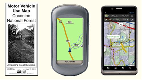
These new rules went into effect in May 2012. The Forest Service now issues annually
a paper Motor Vehicle User Map indicating the remaining open roads and camping corridors.
There’s a PDF version on their website, and a Garmin-compatible electronic version as well.
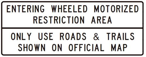
What they did NOT do was make any attempt to mark closed roads with signage. There is
now a small sign at many major forest road entry points that says “USE ONLY ROADS AND
TRAILS SHOWN ON OFFICIAL MAP”. If you don’t have the map or haven’t heard about the rule
changes you might think this means “stay on roads that are marked with forest road numbers.”
That’s not the case - and in fact, the majority of numbered roads are now officially closed!
They’re still there, many in good shape, but there are no ROAD CLOSED signs. Nor are there
any markers for the designated parking or camping areas. (The Forest Service claims that
signage is too expensive and too easily vandalized to be practical).
A large proportion of existing, long-used dispersed camp sites with good parking, fire
rings, etc. are now officially off-limits. And the newly designated camping corridors
often include terrain that is unsuitable to actually camp on. The new rules, by design,
often put campsites too close to a well-traveled road, subjecting campers to dust & noise.
Enforcement Impractical; Public Poorly Informed
Due to a shortage of resources, the Forest Service has no realistic plan to effectively
enforce all these new rules, and they are not likely to receive help from other agencies.
Coconino County Sheriff William Pribil has been outspoken in his opposition to the
Travel Management rules, and the Arizona Game and Fish department is on record as
believing the restrictions to be unreasonable in many cases. In 2013, the Arizona
legislature passed HB2551 which specifically gave Game & Fish officers discretion to
ignore enforcement of travel management rules on Federal lands, prioritizing their role
as wildlife managers.
In my experience – talking to folks I met using forest roads or camped nearby – most
users still don’t know much about the changes. Every summer since 2012, I have seen
campers in “off limits” sites and obvious signs of use on “closed” roads. One major
reason for the lack of public knowledge is the apathy of print and TV media outside
the immediate area. The Forest Service publishes their proposed actions and announces
opportunities for public input in the nearest newspaper to the affected forest, which
for the Coconino is Flagstaff’s Arizona Daily Sun. The Sun has published a number of
articles and editorial comments on the subject and taken a balanced stance. But
even though the majority of forest users – hunters and campers - probably travel from
the Phoenix area, the Arizona Republic has steadfastly refused to cover the issue. I
contacted their outdoors reporter in 2008 and was told there was “no interest” in the
story.
The forest service has made an attempt to contact campers and hand out maps on certain
roads, and on some of the more popular weekends. Later in the season, when deer and
elk hunters are afield, there seems to be very little presence at all. Nevertheless,
forest rangers can cite violators. In the 2013 and 2014 Travel Management Monitoring
Reports, statistics on enforcement activity were tabulated. Examples were made of
some off-roaders who caused significant damage or were involved in other criminal
activity, but most of the contacts were warnings. Enforcement is primarily focused
on sensitive areas and areas near private property or where complaints have been lodged.
|
A Warning to Hunters?
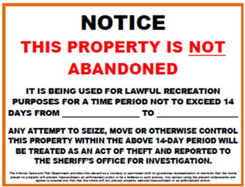
A longstanding federal regulation limits the length of time one may camp continuously
in the forest to 14 days. It is common practice, especially for hunters, to set up
camp for the 2-week “season” and leave trailers, tents, etc. in place during resupply
trips to town. In August 2013, the Coconino Forest issued a press release indicating
that any camp trailer left unattended for more than 72 hours could be considered
abandoned and could be subject to confiscation. The Arizona Game & Fish Commission
and the Coconino County Sheriff’s Department have both gone on record as opposed to
this policy and have refused to cooperate in its enforcement. The AzGFD has
recommended that hunters placard their campsites to document their intent to follow
the 14-day rule.
The Forest Service later walked this back a bit, saying they were not targeting hunters.
Their December 2013 press release reads in part “Forest visitors camping and actively
engaging in hunting or other recreational activities are not at risk of being cited or
having their property considered abandoned after 72 hours. Hunters and other campers
have never been required to move camp every 72 hours and will not be required to do so
in the future.”
Other Forests in Arizona
The Kaibab & Prescott National Forests have completed the TMR process and published
Motor Vehicle Use Maps. In both cases the mileage of open roads was reduced, but not
as drastically as occurred on the Coconino. Similar camping restrictions are in place,
significantly limiting the areas in which motorized camping is permitted. The Kaibab
Forest has attempted to place signage in the field to indicate closed roads.
The Tonto NF has released a draft impact statement in June 2014 containing alternative
proposals which would result in closing between 5% and 75% of the existing roads. The
Forest Service has stated their preference for Alternative C, which would close 62% of
the roads.
The Apache-Sitgreaves NF has placed Travel Management on hold, claiming the Wallow
Fire of 2011 has delayed efforts. A Transportation Analysis has been published and
some alternatives have been produced. Currently, road maps are available showing open
and closed routes and designated camping areas. Camping near the Rim Lakes area has
been regulated for some time due to the popularity of the area.
You Can Influence the Process (Maybe…)
To their credit, the Forest Service has solicited public comment on the rules and promised
to consider suggestions. They made some minor corrections to the Coconino maps in 2015
and have proposed more substantial changes, including re-opening some popular roads and
camping areas in 2016. Significant changes to the plan have to go through the National
Environmental Policy Act (NEPA) process which involves the usual bureaucratic morass of
studies, hearings, notices, etc.
For the Coconino, the contact person is Mike Dechter, Travel Management Project Leader,
Coconino National Forest, 1824 South Thompson St., Flagstaff, AZ 86001; (928) 527-3620.
I have talked to Mike in the past; he’s a reasonable guy and understands the concerns but
he has a lot of conflicting opinions to reconcile. It would be good to add your comments
as they do seem to listen even if they move very slowly. I was pleasantly surprised to
find that one of my suggestions – reopening a road to a favorite camping spot – actually
made it into the list of proposed actions. The comment period for the proposed 2016
changes runs through July 31, 2016. Presumably any changes would not become effective
until the 2017 season.
The email address is comments-southwestern-coconino@fs.fed.us, or you can use their web
form linked below.
References
Travel management Rule:
http://www.fs.fed.us/recreation/programs/ohv/final.pdf
Coconino NF:
http://www.fs.usda.gov/detail/coconino/landmanagement/projects/?cid=stelprdb5263010
Coconino NF MVUM Comment Form:
http://www.fs.usda.gov/detailfull/coconino/landmanagement/projects/?cid=stelprdb5306221&width=full
Kaibab NF:
http://www.fs.usda.gov/detail/kaibab/maps-pubs/?cid=fseprd490027
Prescott NF:
http://www.fs.usda.gov/detail/prescott/home/?cid=STELPRDB5343602
Tonto NF:
http://data.ecosystem-management.org/nepaweb/fs-usda-pop.php?project=28967
Apache-Sitgreaves NF:
http://www.fs.usda.gov/detail/asnf/home/?cid=stelprdb5200750
Coconino County Sheriff:
http://azdailysun.com/news/local/govt-and-politics/sheriff-objects-to-road-closures/article_cb7368ed-50fb-5ebe-a5a8-09c072bacb9a.html
AzGFD Warning to Hunters:
http://azgfd.net/artman/publish/NewsMedia/Warning-to-Arizona-Hunters-Camping-on-the-Coconino-Kaibab-and-Prescott-National-Forests.shtml
Forest Service “Clarification” Letter:
http://www.fs.usda.gov/detail/kaibab/news-events/?cid=STELPRDB5443136

![]()
